Iowa weather: Rain moves in Tuesday followed by wind and snow as a winter storm approaches Wednesday
 Updated: 10:28 PM CST Mar 3, 2025
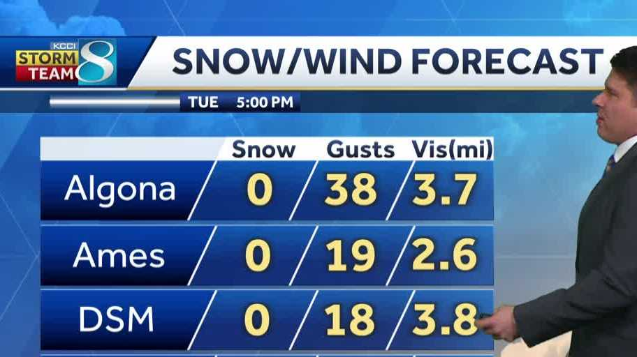
NO. OKAY. COMBINATION. WE HAVE GOT SOME WEATHER TO TALK ABOUT TONIGHT. YEAH, NOT A GOOD COMBINATION EITHER. YEAH. MOTHER NATURE IS DEALING US, JASON. THOSE STRONG WINDS, THE RAIN, THE SNOW, IT’S GOING TO BE PRETTY YUCKY OUT THERE. IT’S GOING TO BE TERRIBLE. YEAH. I MEAN, REALLY, THAT SYSTEM. WE’RE ALREADY FEELING SOME IMPACTS OF THAT WITH RAIN THAT HAS PUSHED IN. WE’LL SEE POTENTIAL FOR SOME STORMS AS WE HEAD THROUGH THE OVERNIGHT. AND THEN WE’VE GOT THAT CHANCE FOR THAT TRANSITION TO SNOW LATE TUESDAY INTO WEDNESDAY. AREAS LIKE ALGONA LIKELY GOING TO PICK ON THAT, PICK UP ON THAT A LITTLE BIT QUICKER THAN THE REST OF US BY 8 P.M., OR NEARLY AN INCH AND A HALF DOWN 50 MILE PER HOUR WIND GUSTS, NO VISIBILITY. AND THAT’S GOING TO BE ALL OF US BEFORE YOU KNOW IT. HERE YOU CAN SEE THAT SNOW STARTS TO BUILD BY 3:00 IN THE MORNING. VISIBILITY IS A MILE OR LESS FOR MANY OF US. AND AGAIN, SNOWFALL AMOUNTS IN A LOT OF LOCATIONS MAY NOT BE THAT SIGNIFICANT. WE COULD SEE A BAND OF AROUND 4 TO 6IN SET UP FROM ALGONA ALL THE WAY DOWN THROUGH AROUND CARROLL OR SO, BUT SOUTHEAST OF THERE. A LOT OF US GOING TO BE PICKING UP ON MAYBE ONE, 2 OR 3IN. SO IT’S NOT NECESSARILY THE AMOUNT OF SNOW THAT WE’RE TALKING ABOUT, BUT THAT SNOW COMBINED WITH THESE WINDS AND SOME OF US COULD SEE WINDS IN EXCESS OF 60MPH, WHICH IS GOING TO LEAD TO VISIBILITY CONCERNS FOR A BIT HERE ACROSS A GOOD PORTION OF THE STATE. SO AS WE LOOK AT WHERE WE SIT RIGHT NOW, A LITTLE BIT OF RAIN STILL FALLING. FORT DODGE UPWARDS TOWARDS IOWA FALLS. YOU ZOOM OUT STATEWIDE, STILL MONITORING THAT SOUTHWESTERN PORTION OF THE STATE FOR ANY CHANCE OF THOSE STORMS TO FIRE UP, WHICH WILL LIKELY BE THROUGHOUT THE OVERNIGHT HOURS. AND WE’VE GOT A HIGH WIND WARNING. HIGH WIND WATCH. EXCUSE ME. IN PLACE AT 6 P.M. TUESDAY THROUGH 3 P.M. ON WEDNESDAY. AGAIN, A GOOD PORTION OF THIS AREA OF THE STATE IS LIKELY GOING TO BE ON TAP FOR WINDS AROUND 50 TO 60MPH. I WOULD NOT DOUBT THAT. WE SEE WINDS IN EXCESS OF 60MPH ACROSS A GOOD PORTION OF THE STATE. SO A PRETTY, PRETTY WICKED SETUP AS WE WORK OUR WAY INTO THE OVERNIGHT, YOU CAN SEE THOSE STORMS FIRE THEIR WAY THROUGH AGAIN. MAINLY JUST HAIL MAKERS. NOT GOING TO SEE ANYTHING MORE IMPACTFUL THAN THAT WITH THOSE. BUT BY TUESDAY, LOOK AT ALL THE MOISTURE WE’VE GOT AND THEN THE WINDS START TO RAMP DOWN ON THE BACKSIDE OF THIS SYSTEM. WE’RE TALKING A TRANSITION OVER TO SNOW THAT’S GOING TO BE ACCOMPANIED BY THOSE VERY STRONG WINDS. BY NOON, 62MPH WIND GUSTS FOR SIOUX CITY, 64 FOR COUNCIL BLUFFS. AND YOU CAN SEE RIGHT ON THE EDGE OF THIS THING OUT IN FRONT OF IT WHERE THE RAIN IS. WINDS ARE AROUND 30 TO 40MPH, BUT YOU GET CLOSE TO THAT TRANSITIONARY ZONE AND MAN ALIVE. THOSE WINDS ARE SCREAMING. AND EVEN AFTER THAT, SNOW STOPS FALLING WILL LIKELY CARRY A PERIOD OF TIME INTO THE EARLY EVENING HOURS WHERE THOSE WINDS STILL IN EXCESS OF 40MPH, WHICH MEANS WE WILL LIKELY STILL BE DEALING WITH BLOWING SNOW INTO WEDNESDAY NIGHT. SO A PRETTY MOISTURE LADEN SYSTEM. WE HAVE GOT AN INCH TO TWO INCHES, FAIRLY WIDESPREAD ACROSS THE STATE FROM THIS, AND AS FAR AS HOW MUCH SNOW YOU CAN EXPECT. AGAIN, THE MAIN ZONE WHERE WE’RE PICKING UP THE HIGHEST AMOUNTS, CALLED THE DEFORMATION ZONE. YOU CAN SEE THAT FROM MASON CITY ALL THE WAY DOWN THROUGH AROUND ATLANTIC OR SO. THERE WILL BE POCKETS. I THINK THAT COULD BE IN EXCESS OF SIX INCHES. BUT AGAIN, WITH THE MELTING THAT WE’RE GOING TO HAVE IN THE CRAZY WINDS, IT’S REALLY GOING TO BE A HARD, A HARD TASK TO ACTUALLY GET A GOOD MEASURE AND A GOOD READ ON THE SNOW THAT HAS FALLEN. WE’RE DOWN TO 36 ON WEDNESDAY, THOUGH. MORE SNOW CHANCES ON FRIDAY. IF YOU THOUGHT WINTER WAS OVER. WELL, WE’VE GOT A12 WALLOP ON THE WAY AS
Iowa weather: Rain moves in Tuesday followed by wind and snow as a winter storm approaches Wednesday

Updated: 10:28 PM CST Mar 3, 2025
A quiet and pleasant start to the workweek on Monday, but our fate lies before us as rain starts to push its way in late tonight.Interactive Radar | Weather Alerts We’ll see rain continue for much of the day Tuesday and could hear some rumbles of thunder accompanied by some small hail as well. Temperatures Tuesday stay mild with highs topping out in the mid-50s, though we’ll be cloudy and rainy for much of the day. Cold air starts to work its way in on the backside of the system, starting a transition from rain to snow late Tuesday night into Wednesday morning. The low pressure causing this mess will continue to deepen/strengthen further, pushing our already gusty winds to around 50mph+ at times. As heavy snow falls and winds pick up we’ll likely see difficult travel conditions and limited visibility with pockets of blizzard conditions possible. The Wednesday morning commute is looking like it may be difficult, especially for portions of the state that see the most snow. Right now that sits on an axis from around Mason City to Council Bluffs with around 6″ possible. Even areas that don’t pick up more than 1-2″ will see that snow blown around quite a bit leading to continued slick spots on the roads even after the snow has stopped falling by late morning. Winds stay gusty into the afternoon before finally dying back down to gusts around 20-25 mph by the evening. Temperatures take a huge hit Wednesday with highs topping out in the mid-30s. We’ll gain some ground back Thursday with temperatures pushing back into the mid-40s, but by Thursday night another system will track its way through Missouri bringing a mix of precipitation across Iowa into Friday. This may again make for a slick morning commute early Friday. Temperatures will dip back into the low 40s Friday and bounce back into the mid-50s by the end of the weekend.Iowa weather forecastToday: Partly cloudy skies in the morning, then more clouds in the afternoon. Slim chance of a morning shower to the east. High 59F. Winds S at 10 to 20 mph. Gusts up to 25 mph.Tonight: Cloudy skies early with rain developing later at night. Low 48F. Winds SSE at 10 to 20 mph.Tomorrow: Rain likely. Thunder possible. High 54F. Winds shifting from SE to N at 10 to 15 mph.Tomorrow Night: Windy with rain, then snow overnight. Low 29F. Winds N at 25 to 30 mph. Winds could occasionally gust over 50 mph.
DES MOINES, Iowa —A quiet and pleasant start to the workweek on Monday, but our fate lies before us as rain starts to push its way in late tonight.
Interactive Radar | Weather Alerts

We’ll see rain continue for much of the day Tuesday and could hear some rumbles of thunder accompanied by some small hail as well. Temperatures Tuesday stay mild with highs topping out in the mid-50s, though we’ll be cloudy and rainy for much of the day.
Cold air starts to work its way in on the backside of the system, starting a transition from rain to snow late Tuesday night into Wednesday morning. The low pressure causing this mess will continue to deepen/strengthen further, pushing our already gusty winds to around 50mph+ at times. As heavy snow falls and winds pick up we’ll likely see difficult travel conditions and limited visibility with pockets of blizzard conditions possible.
The Wednesday morning commute is looking like it may be difficult, especially for portions of the state that see the most snow. Right now that sits on an axis from around Mason City to Council Bluffs with around 6″ possible. Even areas that don’t pick up more than 1-2″ will see that snow blown around quite a bit leading to continued slick spots on the roads even after the snow has stopped falling by late morning. Winds stay gusty into the afternoon before finally dying back down to gusts around 20-25 mph by the evening. Temperatures take a huge hit Wednesday with highs topping out in the mid-30s.
We’ll gain some ground back Thursday with temperatures pushing back into the mid-40s, but by Thursday night another system will track its way through Missouri bringing a mix of precipitation across Iowa into Friday. This may again make for a slick morning commute early Friday.

Temperatures will dip back into the low 40s Friday and bounce back into the mid-50s by the end of the weekend.
Iowa weather forecast
Today: Partly cloudy skies in the morning, then more clouds in the afternoon. Slim chance of a morning shower to the east. High 59F. Winds S at 10 to 20 mph. Gusts up to 25 mph.
Tonight: Cloudy skies early with rain developing later at night. Low 48F. Winds SSE at 10 to 20 mph.
Tomorrow: Rain likely. Thunder possible. High 54F. Winds shifting from SE to N at 10 to 15 mph.
Tomorrow Night: Windy with rain, then snow overnight. Low 29F. Winds N at 25 to 30 mph. Winds could occasionally gust over 50 mph.