- First Alert Weather Day In Effect Today For Wind Advisory & Evening Severe Storms
- Fast Moving Line of Storms Hits From West to East 7PM Today – 1AM Saturday
- 75+ MPH Winds, Tornadoes, and Hail Possible
Click here to download the First Alert Weather App

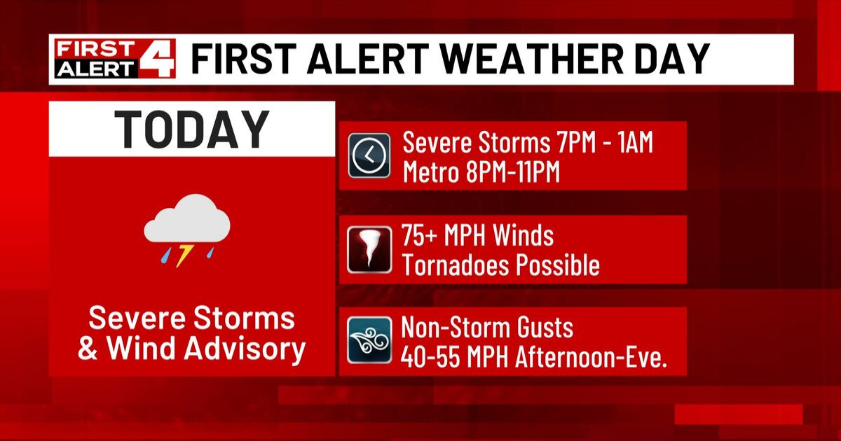
FIRST ALERT WEATHER DAY TODAY: Our severe weather threat this evening remains at a level 4 (out of 5). Pockets of destructive winds are likely. Higher end gusts of 75+ MPH are possible, along with potentially strong tornadoes. This relatively high-level risk does not guarantee that your particular area will be hit by severe weather, but you need to remain alert and weather-aware this evening. Make sure you have multiple ways to get warnings (like the First Alert 4 Weather App with location based alerts — linked above) and know where to take shelter if necessary.

Here’s how we expect this to unfold. A fast moving line of thunderstorms will develop this afternoon in western and central Missouri. These storms will strengthen and move through our area during the evening, mainly between 7PM today and 1AM Saturday, moving very quickly from west to east. Our latest estimate for the St. Louis metropolitan area is 8-11 PM. At this point, we feel confident in this timing as our forecast models have locked in and are in good agreement.
In addition to the risk of severe storms later today, this will also be a windy day. A Wind Advisory is in effect this afternoon and evening with non-storm wind gusts up to 55 MPH. That’s strong enough to blow around loose objects and cause weak tree limbs to come down.

Behind today’s weather system, we are cooler but still mild Saturday with highs remaining above normal in the low 70s. There is a fairly low chance of showers Saturday, mainly south and east of St. Louis. As of now, this rain looks light and spotty. Significantly cooler air arrives Sunday before temperatures quickly rebound for St. Patrick’s Day.

Copyright 2024 KMOV. All rights reserved.