DENVER — A powerful spring storm arrived in Colorado Monday afternoon, and the 9NEWS Weather Impact Team has issued a Weather Impact Alert for Tuesday.
A few convective storms formed on the Front Range and eastern plains Monday, producing anything from thunder and lightning to graupel, small hail and rain. It didn’t take too long for snow showers to develop in the Denver area, with some heavy snowfall occurring south of the city around 9 or 10 p.m. Heavy snow can overcome the warm air and ground temperatures to produce brief driving impacts at times, so be extra careful traveling late Monday night and early Tuesday.
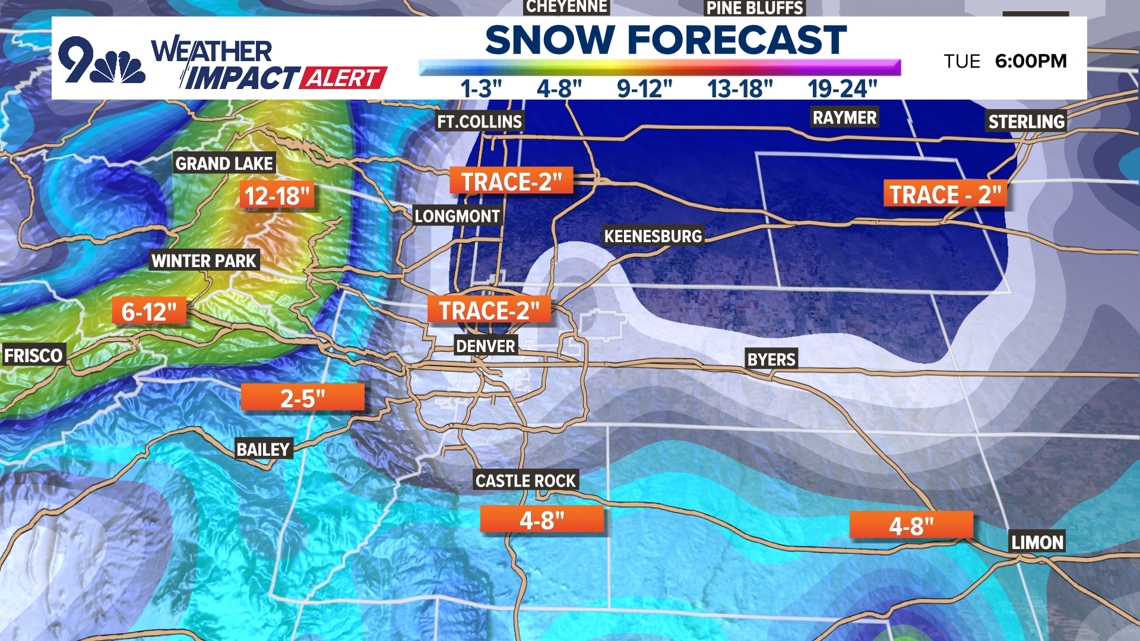
Those heavy snow showers will be possible in the Denver area until about sunrise, when the snow is expected to move off to the eastern plains. Even with several hours of heavy snow, it’s likely that only 1-2 inches of slush is all that remains on the ground by 7 a.m. because of the overall warm temperatures causing melting and compression.

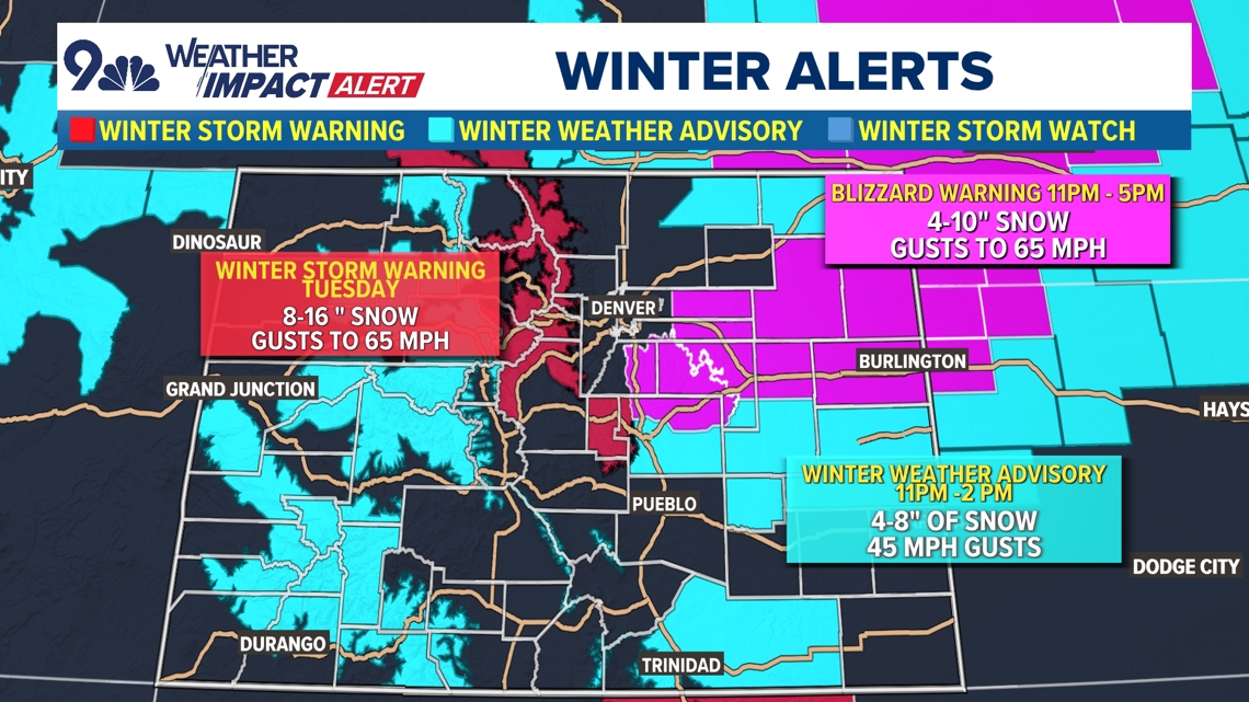
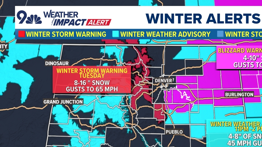
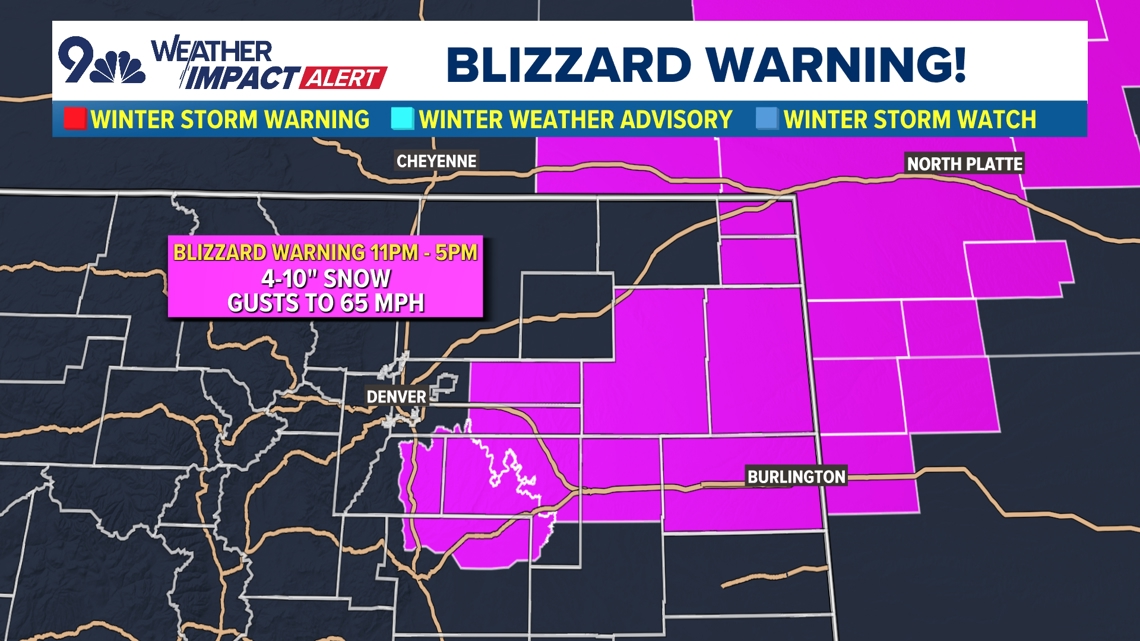
A Blizzard Warning has been issued east of the Denver metro area. Elbert County and the northeastern plains are under the Blizzard Warning through Tuesday.

A blizzard means limited visibility because of wind. One of the main areas of concern with this storm is on the Palmer Divide and eastern plains, where blizzard conditions are likely to develop in the overnight hours into Tuesday morning.
Highway 86 from Castle Rock to Limon, as well as Interstate 70 from Denver International Airport to the Kansas state line, could see major impacts from heavy snow blowing in 40-60 mph winds creating near zero visibility.
Highway 36, Highway 34 and Interstate 76 to the north are slightly less likely to have blizzard conditions, but snow and high wind impacts are still expected.
The snow is forecast to move out of Colorado by about 4 p.m. on Tuesday, but blowing snow could remain highly impactful well into the night.


Snow and wind are also expected to have high impacts to mountain travel Monday and Tuesday. The Front Range mountains could start to see heavy snow showers starting Monday, where 8-18 inches of snow is in the forecast by Tuesday night in places like Berthoud Pass, the Eisenhower/Johnson tunnels, Loveland Pass, and Kenosha Pass.
Wind gusts of 30-45 mph will add to the travel troubles in the mountains, helping to decrease visibility on the roads.
Heavy snow showers are expected to drop down to 6,000 feet by about 8 or 9 p.m. Monday, which means the Interstate 70 mountain corridor will be slick, slow and difficult to travel from Golden to Vail Pass overnight into Tuesday morning.
The foothills are a big question mark as far as total snow accumulation goes because of the eastward forecast of the low-pressure center, but 2-5 inches could still fall in places like Conifer, Evergreen Genesee and Estes Park.

The mountains on the western slope are expected to see less snow, but there are winter weather advisories in place for about 4-8 inches of accumulation.

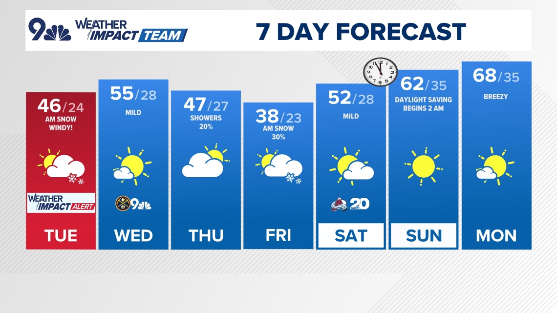
- TUESDAY: Areas of snow in the morning along with high wind. High 45. Partial clearing overnight, low 22.
- WEDNESDAY: Mostly sunny with a high 51, low 28.
- THURSDAY: Increasing clouds with rain developing in the afternoon and changing to snow late. High 52, low 27.
- FRIDAY: Morning snow then possibly switching back to rain with a high of 38, low 23.
- SATURDAY: Mostly sunny and warmer, high around 53. Low 28.
- SUNDAY: Sunny and dry, high 63, low 35.