- Snow showers move in Monday night
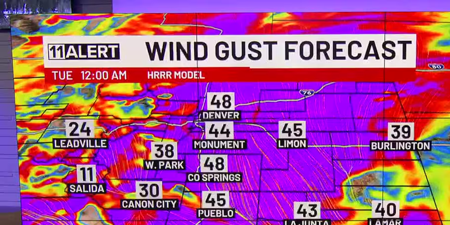
- Strong wind gusts continue Tuesday
- Heavy snow + heavy winds = blizzard conditions
MONDAY NIGHT: Plan on strong winds and PM snow/rain showers. We’ll see initial melting as the ground is warm. Blizzard warnings are active for northern El Paso County and east along the I-70 corridor. The bulk of this system will arrive overnight, but still expect a messy morning commute with low visibility. Accumulations will be more the further north you go. We’ll see some snow melt…
Snow accumulations Monday night – Tuesday:
- Colorado Springs: 1-5″
- Monument: 6-10″
- Palmer Lake: 8-12+”
- Manitou Springs: 3-5″
- Woodland Park: 10-15+”
- Cripple Creek: 10-15+”
- Falcon: 6-10″
- Black Forest: 8-12″
- Fountain: 1-3″
- Pueblo: Trace-1″
- Rye: 1-4″
- Canon City: Trace-1″
- Kim: 2-6″
TUESDAY: Snow lingers through the morning hours with low visibility. Gusts could be over 65 mph at times, making for blowing snow. We can’t rule out another flurry through the afternoon either, but we are expected to mostly stay dry. Temperatures remain cool in the afternoon.
Stay updated by downloading the KKTV 11 Breaking Weather App:

THE REST OF THE WEEK: Wednesday remains dry with seasonal temperatures, but later in the week we are alerting you first to more unsettled weather Thursday into Friday. Details to come.
Copyright 2025 KKTV. All rights reserved.