Snow expected into Thursday

LIVE: Severe weather radar around Chicago area
CHICAGO (WLS) — A Tornado Watch has been issued for some southwest suburbs and northwest Indiana, as a strong round of possibly severe storms is expected Wednesday afternoon and evening.
A Tornado Watch is in effect until 9 p.m. for Kankakee and Livingston counties in Illinois and Benton and Newton counties in Indiana, the National Weather Service said.

A Severe Thunderstorm Warning is in effect until 7 p.m. CT for LaPorte County, Indiana and Berrien County, Michigan.
A Tornado Warning was in effect for Cook, DuPage, Will and Kankakee counties in Illinois, and Lake and Newton counties in Indiana, but has since expired.
The Chicago weather forecast Wednesday includes a Tornado Watch, a Severe Thunderstorm Warning for suburbs and northwest Indiana, and snow Thursday.
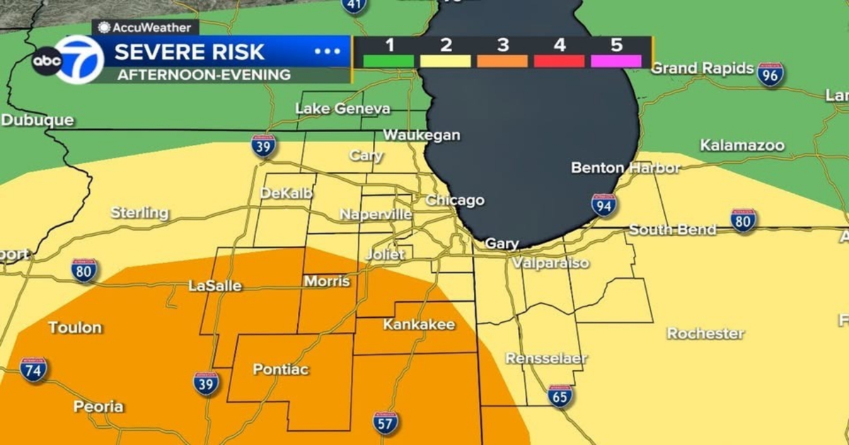
Much of the Chicago area is under a Level 2 risk of severe weather from about 3 to 8 p.m. The southwest suburbs are under a Level 3 risk and far north suburbs into Wisconsin are under a Level 1 risk.

ABC7 Chicago is now streaming 24/7. Click here to watch
There were scattered severe thunderstorms across the area, with the threat for high winds and large hail, especially south of Interstate 88.
As of 6:20 p.m., at least 2,996 ComEd customers were without power in the Chicago area, ComEd said. The most affected areas were Steger and Elgin.
Chicago’s airports saw delays and cancellations amid the severe weather. As of 6:22 p.m., there were 122 cancellations and delays averaging 75 minutes at O’Hare, and there were 43 cancellations and delays averaging 21 minutes at Midway, according to the Department of Aviation.
Tornado sirens could be heard in New Lenox as the first Tornado Warning was issued for Will County just after 5 p.m. Wednesday.

Clouds appeared to rotate as storms moved through New Lenox Wednesday.
Will County Emergency Management said a semi and trailers were blown onto their sides by strong wind near West Laraway Road and South Cedar Road.
A trailer was on its side Wednesday after storms blew through New Lenox.
A Wind Advisory will go into effect for most of the area at 10 p.m. through 7 a.m. Thursday.
Once the storms move out, snow showers will push in from the north, especially north of Interstate 80.
Most of the snow will fall before the Thursday morning commute.
But, a slushy dusting to an inch or 2 of accumulation will be possible with some isolated spots seeing as much as 3 inches of snow.
Severe storms caused damage across the Chicago area late Friday night into Saturday morning.
Weather Alerts | Live Doppler Radar
Cook County Radar | DuPage County Radar | Will County Radar | Lake County Radar (IL) | Kane County Radar | Northwest Indiana Radar
Copyright © 2025 WLS-TV. All Rights Reserved.