(KFVS) – We issued a First Alert Action Day through the overnight hours due to the threat of severe storms.
Most of Friday will be warm and breezy but scattered storms will develop to our west Friday afternoon and evening and spread across the Heartland.
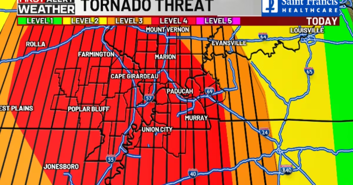
The only change we have seen in the forecast is a slight increase in the tornado threat.
SPC has us in a level 4/moderate risk for severe weather.

Wind Advisories are in effect for most of the area.
Chief Meteorologist Grant Dade says it appears likely that a broken line of storms will develop this evening and move across the Heartland.
The atmosphere is very conducive for severe weather tonight. Any storm that can develop and become mature would likely produce hail up to baseball size, winds up to 90 miles per hour and strong tornadoes.
Grant says the main broken line of storms will enter our western counties between 8 and 10 p.m., reach the Mississippi River between 11 p.m.- 1 a.m., and exit the area between 2 and 3 a.m.

There is a small chance a few isolated storms could develop earlier ahead of the main line so please stay weather aware.
With that said, storms will be scattered, so many will not see storms.
According to the US National Weather Service, a Tornado Emergency was issued for Fremont and Van Buren, Missouri. Van Buren EMD says two people were trapped in a house by Fremont.
Download the KFVS12 First Alert Weather app for updates wherever you are.

Weekend forecast
After a break on Saturday morning, another surge of rain and thunderstorms will develop southwest to northeast by Saturday afternoon.
The severe storm threat on Saturday will be along the eastern edge of our region, especially northwest Tennessee and parts of western Kentucky.
Highs will range from the 60s north to middle 70s far south on Saturday.
Sunday will be breezy and dry but much cooler. Lows Monday morning will be back to near freezing with scattered frost possible.
After that, we’ll see temps rebound along with southwest breezes for a couple of days.
Another cold front will bring a few showers and cooler weather later next week.
Copyright 2025 KFVS. All rights reserved.